

‘The Canva of Maps’ lives up to its name for free interactive mapping

Creating custom interactive maps is fun and simple with Proxi.
It’s not the only free mapping tool, of course. If you’re working with beginners and want to give them the opportunity to compare and analyze map makers, here’s a list of other easy options.
Students typically enjoy playing with new tools and having a menu of options for their story packages. Self-described as “the Canva of Maps,” this tool requires zero code and can generate shareable, interactive, mobile-friendly maps in less than 10 minutes.
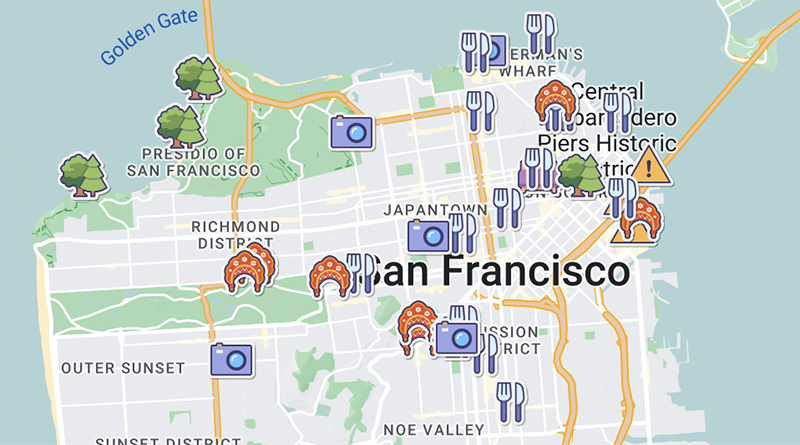
To test it, I made a map to share my favorite San Francisco hangouts as we prepare for the JEA/NSPA National High School Journalism Convention.
Three things I liked:
[1] Customization — It’s easy to name your categories, set your colors and/or choose an icon. I was able to set a geographic boundary for my map, add intro text, simplify the URL and more. Everything is intuitive.
Most of the menus and settings have explainer text and tool tips. As long as you hit the Save button after each stage, the map updates in real-time.
[2] Support — Initially my custom header image wasn’t working, so I sent an email to the support team (contact@proxi.co) and their response was quick and personal. They had a solution and offered to add the image for me if I needed a workaround. It’s rare to feel like I was interacting with a human and getting a genuine offer to help.
[3] Sharing — Anything students make online needs to be easy to push out via social, slick and simple to embed, etc. Proxi options include all of the usual options along with a QR code for use in print media. Nothing was buggy, and everything displayed great. Setting the map to Public mode gives it instant exposure. I especially like this example of how to use it as a storytelling tool for Instagram, as that’s where most of our audience will find it.)
As with other free tools, you have to provide your email address to get back to your saved maps. Make sure students are thinking about long-term use. You may want to create a house account so all of your content lives within your student media outlet’s brand rather than having separate maps tied to individual student creators.
Students will come up with all sorts of ways to incorporate interactive maps, but if they get stuck, Proxi’s public repository of maps is a gold mine of story ideas, too. Their social media accounts heavily promote fun stuff from the MapsGPT collection, which are highly specific, AI-generated maps based on user requests such as where to find meteor showers near San Francisco (while these aren’t as thorough or accurate, they’re fun).
While beginning student journalists may start by making maps for entertainment features (best boba, fun places to hike, cool date spots, shortest Starbucks line), tons of possibilities for hyper-local coverage exist (local businesses hiring, where to find cheap gas, common speed traps), and the process can be a great step toward using interactive maps for taking on important issues and/or telling more stories with data.


Everything looked excellent, and nothing was glitchy. The map becomes instantly visible when it is set to Public mode. See: concrete removal auckland